
The Club as agreed access to the venues for there club members, and members of the public are welcome to attend Club sessions at these venues.
Over Basin, Herefordshire and Gloucestershire Canal
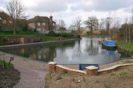
Land Ranger Map No. 162: Grid Reference 816 198: Post Code GL2 8DB
- Leave Gloucester over Westgate Bridge to Newent and Ross-on-Wye.
- Do not take left hand slip lane to Ross-on-Wye but instead continue to roundabout with A40 and Take first exit signed A40 to Ross-on-Wye and Newent.
- Move immediately into right-hand filter lane and turn right at traffic lights across dual carriageway into Horseshoe Drive
- Continue past the “Lock Keepers” restaurant (with array of solar panels on roof) on your right and turn right onto the Herefordshire and Gloucestershire Canal Trust site.
- There is a lockable bollard post to restrict access to the site that may be in the upright position A member with a key (who is familiar with the bollard mechanism) will lower the bollard on their arrival.
- Please secure the site, if you are the last to leave
There is a launching slipway adjacent to the car parking area.
Boats may also be launched from the bank of the basin but this requires a cradle or launching slings as it can be quite a stretch down to the water. Note: Hovercraft are to be used in MODERATION at this location due to noise and the close proximity of our neighbours.
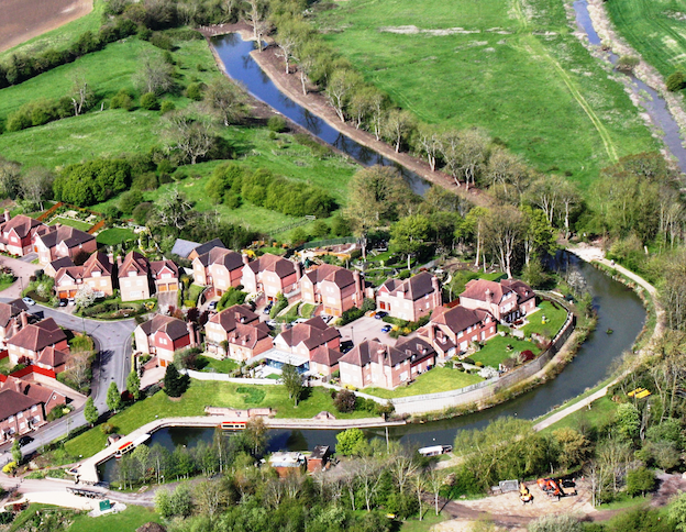
Aerial view of Over Canal Basin and start of 34 mile canal to Hereford
Gloucester – Gloucester Docks
Land Ranger Map No 162: Grid Reference 828 184: Post Code GL1 2LG
a) Approaching from the South on A38 (Western)
- Bypass via Hempstead following through traffic
- At the northern end of bypass turn right towards City centre onto Westgate retail “Island”.
- Bear right and then exit left towards “Gloucester docks” along Quay street.
- Bear left onto Commercial road and take 1st entrance, to the right, into the Docks estate.
- Turn immediately right into the North Warehouse, “Pay and Display” car park.
b) Approaching on A40 (North of City centre)
- Depart at the Over roundabout towards City centre.
- Continue through traffic lights onto Westgate retail “Island”.
- Bear right and then exit left towards “Gloucester docks” along Quay street.
- Bear left onto Commercial road and take 1st entrance, to the right, into the Docks estate.
- Turn immediately right into the North Warehouse, “Pay and Display” car park.
There are several “pay and display” parking areas within the Docks estate, should you wish to park closer to the Barge Arm area, the appropriate fee will need to be paid.
Saul Junction – Junction of Gloucester-Sharpness and Stroud Canals
Land Ranger Map No. 162: Grid Reference 757 090: Post Code GL2 7LA
- Leave Gloucester on A38 South to Bristol.
- After 4 miles from Hardwicke roundabout, pass public house on left.
- Turn right at signpost to Whitminster and follow road, pass church on right and cross small bridge over Stroud canal.
- Turn first right and cross main canal bridge.
- Turn right again and continue to end of track to Wycliffe Boat Club.
- Continue to end of track and park in the “pay and display” area by the Wycliffe Rowing Club (Do not park in the Wycliffe Rowing Club’s area)
- Sail boats from canal bank using Wycliffe Rowing Club slipway, for launching and retrieval.
Ploddy – Private Waters
- The Club has been asked to remove location directions, for site security reasons.
The site is still available, on prebooked occasions but not at any other times.
Any member can use the lake on the prebooked occasions.
For the directions to this location, contact the Club Secretary Secretary
